 |
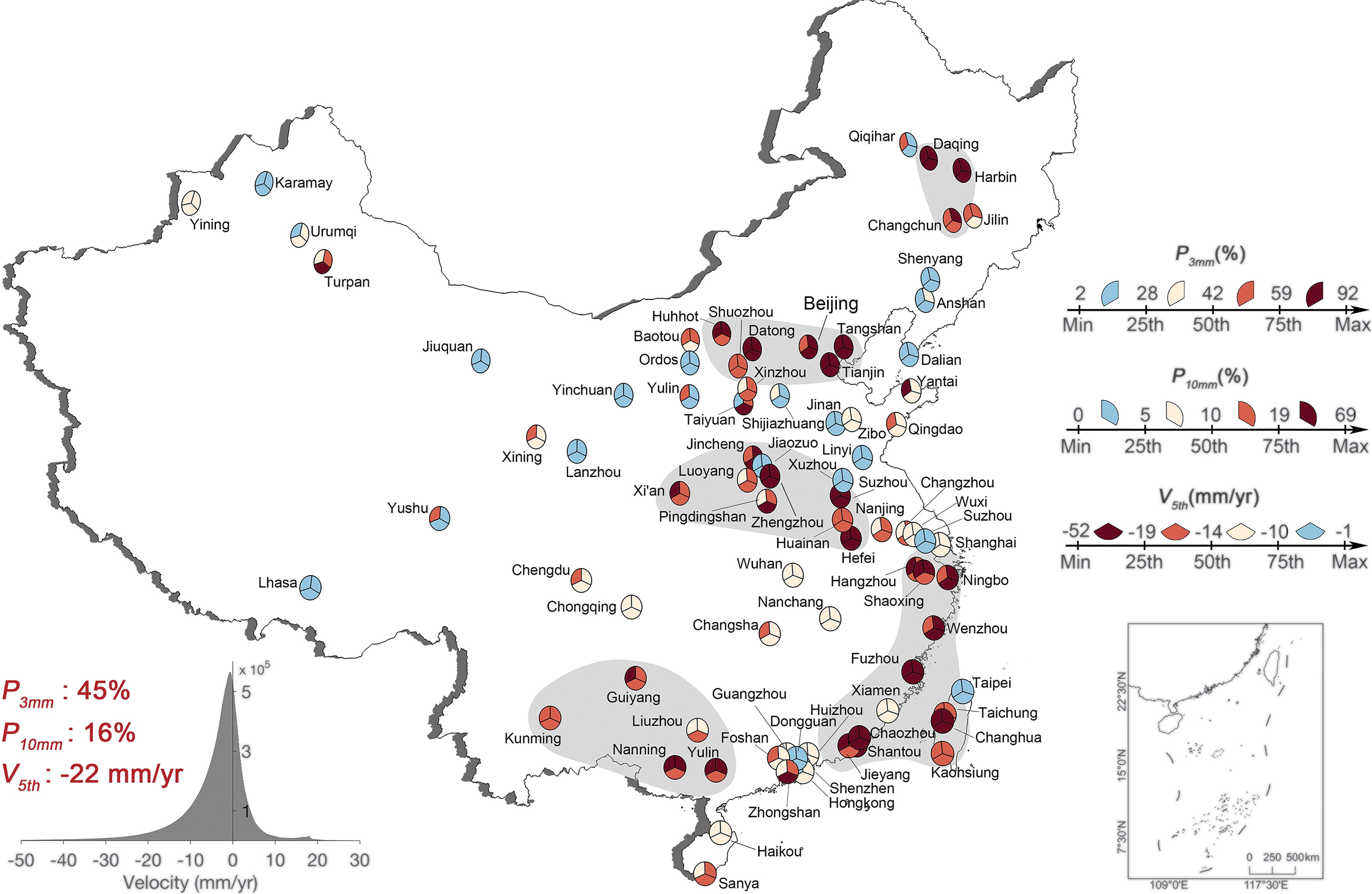
13. A national-scale assessment of land subsidence in China’s major cities.
Ao, Z., Hu, X.†, Tao, S.*, Hu, X., Wang, G., Li, M., Wang, F., Hu, L., Liang, X., Xiao, J., Yusup, A.†, Qi, W., Ran, Q.†, Fang, J., Chang, J., Zeng, Z., Fu, Y., Xue, B., Wang, P., Zhao, K., Li, L., Li, W., Li, Y., Jiang, M., Yang, Y., Shen, H., Zhao, X., Shi, Y., Wu, B., Yan, Z., Wang, M., Su, Y., Hu, T., Ma, Q., Bai, H.†, Wang, L.†, Yang, Z.†, Feng, Y., Zhang, D., Huang, E., Pan, J., Ye, H., Yang, C., Qin, Y., He, C., Guo, Y., Cheng, K., Ren, Y., Yang, H., Zheng, C., Zhu, J., Wang, S., Ji, C., Zhu, B., Liu, H., Tang, Z., Wang, Z., Zhao, S., Tang, Y., Xing, H., Guo, Q., Liu, Y., Fang, J.
Science, 384:301-306 (2024).
[doi]
|
 |
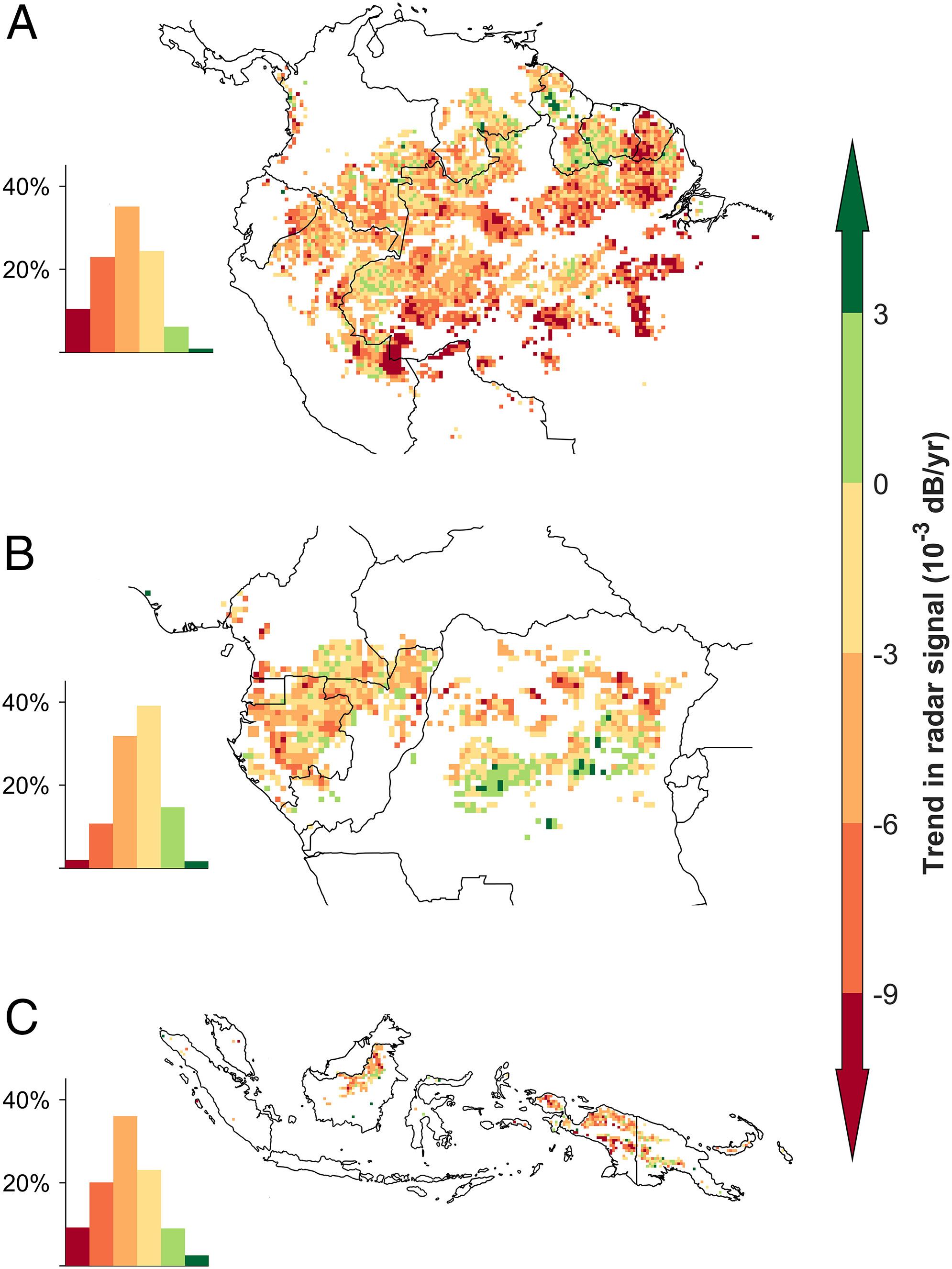
12. Little evidence that Amazonian rainforests are approaching a tipping point.
Tao, S.*, Wigneron, J.*, Chave, J., Tang, Z., Wang, Z., Zhu, J., Guo, Q., Liu, Y. Y., Ciais, P.
Nature Climate Change, 13:1317-1320 (2023).
[doi]
|
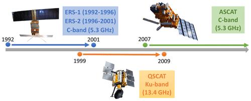 |
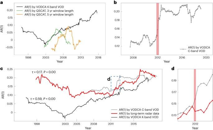
11. A global long-term, high-resolution satellite radar backscatter data record (1992–2022+): merging C-band ERS/ASCAT and Ku-band QSCAT.
Tao, S.*, Ao, Z.*, Wigneron, J., Saatchi, S., Ciais, P., Chave, J., Toan, T. L., Frison, P., Hu, X.†, Chen, C., Fan, L., Wang, M., Zhu, J., Zhao, X., Li, X., Liu, X., Su, Y., Hu, T., Guo, Q., Wang, Z., Tang, Z., Liu, Y. Y.*, Fang, J.
Earth System Science Data, 15:1577-1596 (2023).
[doi]
|
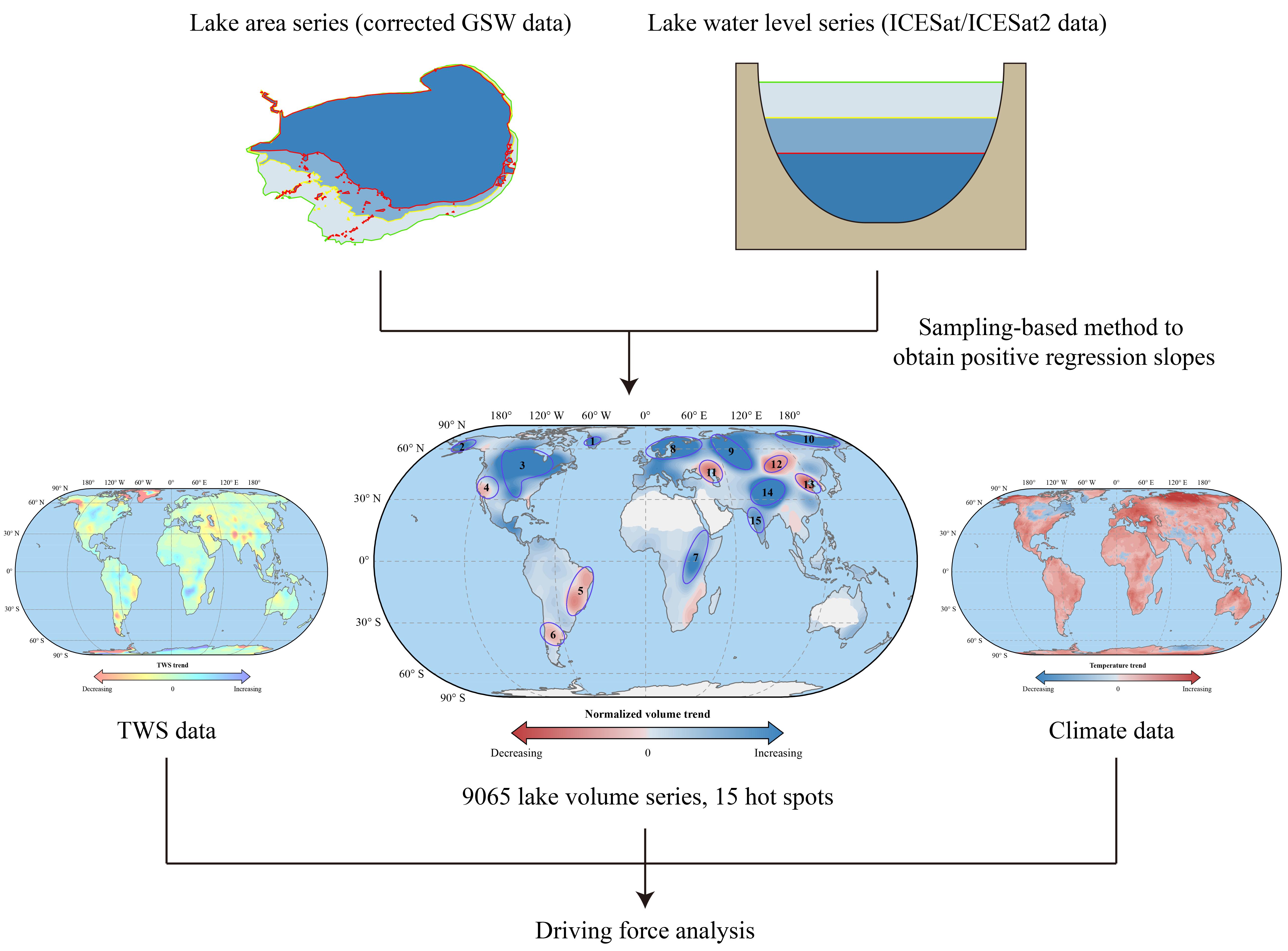 |
10. Decadal Lake Volume Changes (2003–2020) and Driving Forces at a Global Scale.
Feng, Y., Zhang, H., Tao, S.*, Ao, Z., Song, C., Chave, J., Toan, T. L., Xue, B., Zhu, J., Pan, J., Wang, S., Tang, Z., Fang, J.
Remote Sensing, 14:1032 (2022).
[doi]
|
 |
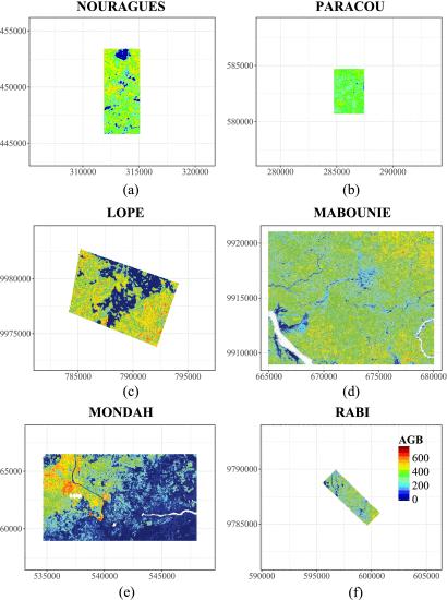
9. Increasing and widespread vulnerability of intact tropical rainforests to repeated droughts.
Tao, S.*, Chave, J.*, Frison, P., Toan, T. L., Ciais, P., Fang, J., Wigneron, J., Santoro, M., Yang, H., Li, X., Labrière, N., Saatchi, S.
Proceedings of the National Academy of Sciences, 119(37):e2116626119 (2022).
[doi]
|
 |
8. Mapping tropical forest trees across large areas with lightweight cost-effective terrestrial laser scanning.
Tao, S.*, Labrière, N., Calders, K., Fischer, F. J., Rau, E., Plaisance, L., Chave, J.*
Annals of Forest Science, 78:103 (2021).
[doi]
|
 |
7. Changes in China's water resources in the early 21st century.
Tao, S., Zhang, H., Feng, Y., Zhu, J., Cai, Q., Xiong, X., Ma, S., Fang, L., Fang, W., Tian, D., Zhao, X., Fang, J.*
Frontiers in Ecology and the Environment, 18:188-193 (2020).
[doi]
|
 |
6. Changes in China's lakes: Climate and human impacts.
Tao, S., Fang, J.*, Ma, S., Cai, Q., Xiong, X., Tian, D., Zhao, X., Fang, L., Zhang, H., Zhu, J., Zhao, S.
National Science Review, 7:132–140 (2020).
[doi]
|
 |
5. In situ reference datasets from the TropiSAR and AfriSAR campaigns in support of upcoming spaceborne biomass missions.
Labrière, N.*, Tao, S., Chave, J., Scipal, K., Toan, T., Abernethy, K.
IEEE Journal of Selected Topics in Applied Earth Observations and Remote Sensing, 11:3617-3627 (2018).
[doi]
|
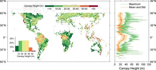 |
4. Global patterns and determinants of forest canopy height.
Tao, S., Guo, Q., Li, C., Wang, Z., Fang, J.*
Ecology, 97:3265-3270 (2016).
[doi]
|
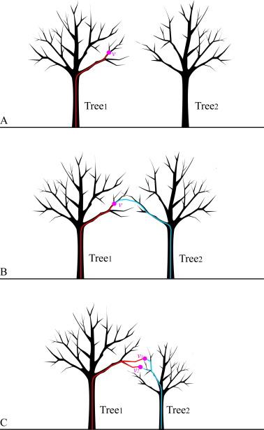 |
3. Segmenting tree crowns from terrestrial and mobile LiDAR data by exploring ecological theories.
Tao, S., Wu, F., Guo, Q.*, Wang, Y., Li, W., Xue, B., Hu, X., Li, P., Tian, D., Li, C., Yao, H., Li, Y., Xu, G., Fang, J.
ISPRS Journal of Photogrammetry and Remote Sensing, 110:66-76 (2015).
[doi]
|
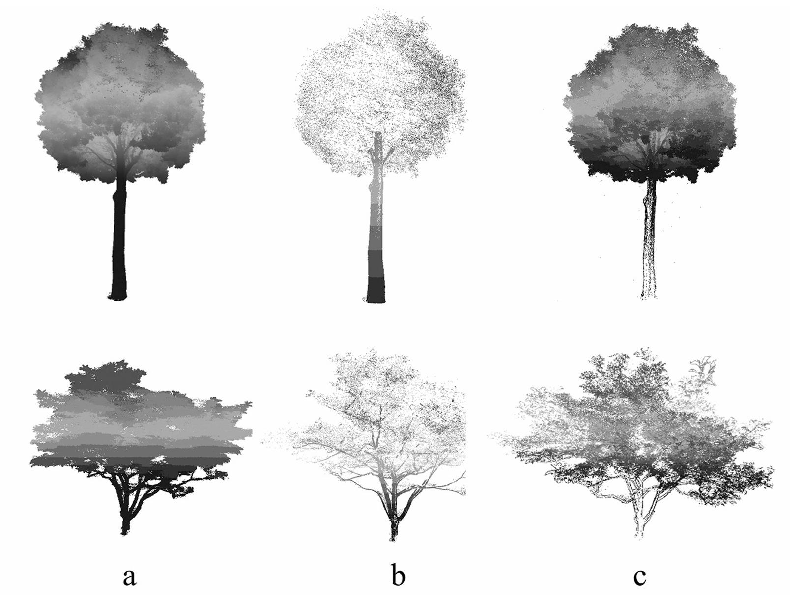 |
2. A geometric method for wood-leaf separation using terrestrial and simulated LiDAR data.
Tao, S., Guo, Q.*, Xu, S., Su, Y., Li, Y., Wu, F.
Photogrammetric Engineering & Remote Sensing, 81:767-776 (2015).
[doi]
|
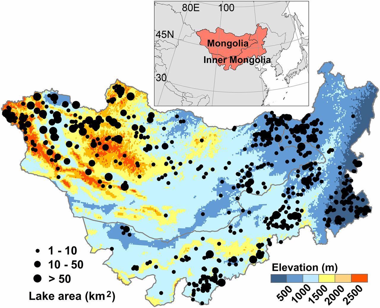 |
1. Rapid loss of lakes on the Mongolian Plateau.
Tao, S., Fang J.*, Zhao, X., Zhao, S., Shen, H., Hu, H., Tang, Z., Wang, Z., Guo, Q.
Proceedings of the National Academy of Sciences, 112:2281-2286 (2015).
[doi]
|